Project Conducted by the Geospatial Section – CERI

🌍🛰️ Project Conducted by the Geospatial Section – CERI
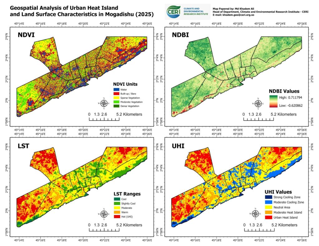
The Geospatial Section of the Climate and Environmental Research Institute (CERI) successfully completed a geospatial research project titled
📍 “Geospatial Analysis of Urban Heat Island and Land Surface Characteristics in Mogadishu (2025)”
This project applied advanced GIS and remote sensing techniques to analyze:
✅ Vegetation Cover (NDVI)
✅ Built-up Areas (NDBI)
✅ Land Surface Temperature (LST)
✅ Urban Heat Island (UHI) Patterns
The analysis highlights the environmental impacts of rapid urbanization in Mogadishu and provides valuable scientific insights for sustainable urban planning, climate resilience, and environmental management.
🛰️ Through spatial analysis and satellite data interpretation, the project supports evidence-based decision-making for greener and more climate-resilient cities.
📌 Conducted by: Geospatial Section – CERI
📌 Focus Area: Urban Climate & Environmental Monitoring
📌 Year: 2025

There are many variations of passages agency we have covered many special events such as fireworks, fairs, parades, races, walks, a Lorem Ipsumpassages agency we have covered many fireworks, fairs, parades, races, walks, a Lorem Ipsum Fasts injecte.

Recent post​

The Climate and Environmental Research Institute (CERI) is an independent, non-profit research Institute based in Somalia. We are committed to advancing climate science, promoting environmental sustainability, and strengthening natural resource governance.

Contact Info

Office Address